Annexed by America?
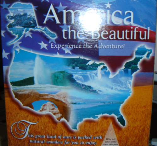
This is a response to the previous “Annexed by Canada” post. I think, MR, you have it backwards. Check out this USA image on a Fred Meyer branded Toasted Oats cereal box. America the Beautiful indeed. Look closely!

This is a response to the previous “Annexed by Canada” post. I think, MR, you have it backwards. Check out this USA image on a Fred Meyer branded Toasted Oats cereal box. America the Beautiful indeed. Look closely!

MRambler Central powered by
WordPress. LetoPrime theme. Wordpress Themes.
Entries (RSS)
and Comments (RSS).
January 10th, 2010 at 4:47 pm
Wow, that’s strange – “Old Glory” is flying high and proud over ALL of Canada!…… Maybe I did have it backwards!…… The U.S.of A. looks as if it is totally covered with water fissures, rampaging floods and desert….. Was that box printed in China?…..
January 10th, 2010 at 4:50 pm
… keep looking …
January 10th, 2010 at 5:45 pm
If you are thinking of New Brunswick, we annexed it. On to B.C.
January 11th, 2010 at 9:26 am
Yeah, Anon, Maine does look a little bloated and I don’t remember seeing the pigtail hanging down on the right side of Alaska either…. I think that is part of British Columbia ……eh?…. I’m now thinking that, not only was the box printed in China, but, they also hired some Chinese sixth grader to do the artwork, or, Jek is right, and our government has secretly begun to annex Canada, one piece at a time….. PD Bob looked this over very carefully, with one eye closed, then he grabbed his Walrus coat, a couple of maps, and a tape measure and was out the door in a flash, shouting something about being left out of the loop…. I suspect we’ll be hearing more on the subject from him…..
January 11th, 2010 at 11:41 pm
Can you see Canada from Alaska?
January 12th, 2010 at 9:02 am
It depends on which map you use, Sunn….. There is no Canada according to the pic in the Post….. By the way, Jek, I thought Hawaii was in the United States?….. I don’t see it, unless, that’s it stuck on top of Maine…..
January 12th, 2010 at 1:48 pm
That bloated area up there by Maine is the national debt it seems to be growing every time I look at the picture. Or maybe its the bankers bonuses.
January 12th, 2010 at 9:05 pm
Nice job Anon. We also got part of Nova Scotia.
This was probably done by a US citizen. A 2006 CNN study sez this about 18-24 state identification:
Pathetic.
January 12th, 2010 at 9:08 pm
MR: Hawaii was indeed on the box at the bottom–hugely out of proportion.
BTW, the image on my last comment was from Globus Tours in case you’re interested in a tour of the “new America”.
January 13th, 2010 at 9:01 am
I wonder how many of those 18-24 year-olds can actually point out on a map the state that they live in…… I guess they could Google it if they really needed to know……
January 13th, 2010 at 10:56 pm
We decide to go ultra-imperialist, and we decide to annex New Brunswick and Nova Scotia?! I don’t ^%$# think so. It should have been Baja or Cuba.
January 15th, 2010 at 11:32 pm
jek, do you suppose this has something to do with the “New World Order”?
January 16th, 2010 at 11:47 am
Sunn: Nah, I just think someone was careless with Photoshop and doesn’t know much about the shape of the US. If it is the NWO, then this is an interesting place to start. Perhaps it is just a diversion.